


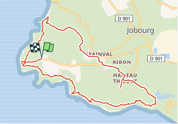
le nez de Jobourg

cron
User

Length
12 km

Max alt
141 m

Uphill gradient
372 m
Km-Effort
16.9 km

Min alt
11 m

Downhill gradient
372 m
Boucle
Yes
Creation date :
2021-03-19 21:39:27.971
Updated on :
2021-03-19 21:40:34.396
3h50
Difficulty : Medium

FREE GPS app for hiking
 SityTrail
IGN / Geographical institutes
SityTrail Plus
The world is yours!
About
Trail Walking of 12 km to be discovered at Normandy, Manche, La Hague. This trail is proposed by cron.
Positioning
Country:
France
Region :
Normandy
Department/Province :
Manche
Municipality :
La Hague
Location:
Jobourg
Start:(Dec)
Start:(UTM)
576585 ; 5503317 (30U) N.
Comments